


Antonio López de Santa Anna, the “Napoleon of the West,” was one of North America’s most infamous leaders.
Although he first fought to defend the Spanish Empire he later became an important figure in the Mexican Rebellion. His actions in the revolution made him a leading figure in the new Mexican Republic. He was elected president in 1833 and quickly seized the government. Within two years, he abolished the Constitution, dissolved the Congress, and presided a dictatorial regime.

Several states resisted Santa Anna’s rule, and Zacatecas took arms in 1835. Santa Anna responded with an army multiple times the size of the rebels’. His army crushed the rebellion within two hours and allowed his troops to ransack the state for days. Within a week, Zacatecas had gone from the largest and wealthiest Mexican state to a looted, burned shell. It was the first example of Santa Anna’s pension for violent, brutal suppression.
Santa Anna’s action in Zacatecas was instrumental in the Texan independence movement. Popular opinion among Texans was divided between staying loyal or rebelling in the first years of the Santa Anna regime. News of the fall of Zacatecas infuriated Texans and turned the dial towards revolution. Within a year, Texas was an autonomous republic.
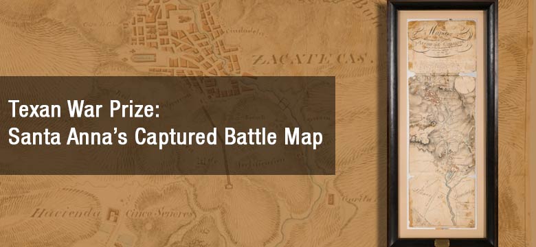
On the evening of April 21, 1836, 900 men under Sam Houston launched an attack on the unsuspecting Mexican Army at San Jacinto. Fighting lasted just 18 minutes before Santa Anna’s troops abandoned their posts and attempted to retreat. Hours later, the general was captured hiding in a marsh. A Battle Map of the Battle of Zacatecas is one of the few Mexican artifacts to have survived what many historians call the most one-sided battle in North American warfare. Directly beneath the map’s ornate title is a 1915 memorandum from noted historian Dr. Alex Dienst confirming the maps’ provenance. As a result, this map is believed to have been a part of Dienst’s extraordinary Texana collection. It would later be a cornerstone of the personal collection of Robert E. Davis. Davis was a preeminent figure in Texana and one of its most respected collectors.
The map on offer is illustrated on four sheets of paper and is backed by a more modern paper to stabilize the piece. There is paper loss in the corners and along a pair of fold marks. However, the illustration remains intact and unmolested. It depicts Zacatecas’ hilly terrain, the town of Guadalupe, and the location of the two warring armies. Lines of advancement for Santa Anna’s troops are depicted as well. Although it is unknown whether the map was drawn in preparation or commemoration of the battle, the map was undoubtedly owned by Santa Anna. It was in the general’s camp equipment and captured by Texan forces after his defeat at San Jacinto.
Heritage Auctions is auctioning the one-of-a-kind relic from the Revolution in its Texana and Western Americana Auction, March 24, 2017. The rare battle map marking Santa Anna’s exertion of power is being offered starting with a reserve of $50,000.
The Zacatecas artifact is not the only map to be auctioned on March 24.
Anton Roessler’s 1874 Latest Map of Texas is one of the most visually impressive maps of the state. The matted work measures 58-by-60 inches and depicts the infrastructure, resources, and terrain of reconstruction-era Texas. The disputed area of Greer County is illustrated as a part of Texas. Anton Roessler was a prominent geologist and businessman. His maps were the best records of agricultural and mineral wealth for decades. Few of his works survive, and are amongst the most desirable maps in the South.
A first edition of Mary Austin Holley’s Texas is expected to attract collectors. The 410-page book was published in 1836 and is one of the most complete records of early Texas. In addition to the first printings of the Texas Declaration of Independence and the Texas Constitution, the book contains troves of Texas Revolution correspondence and business directories. The book also contains Map of State of Coahuila and Texas, a folding map of the new republic with hand coloring and shading. Included in the lot is a receipt for the book from 1938, for $25.00.
By Jake Moon